Climate change is an ongoing process that slowly causes changes across the country.
Between 1901 and 2020, global temperatures rose just over 2 degrees Fahrenheit. But this is only one aspect of climate change. There are also rising sea levels and changes in weather patterns like drought and flooding.
Why do these changes matter? All of them impact necessities we all depend on like water, energy, wildlife, agriculture, ecosystems, transportation, and health.
Climate change impacts vary by region. Some areas may experience warmer winters and increased precipitation, while other regions may experience extended drought.
As we look at climate change facts in general, you’re probably wondering how climate change may affect the plants in your yard.
Typically, trees that are native to a particular area are already adapted. So as the climate changes, they find themselves in a situation they aren’t accustomed to, and this can stress them and make them susceptible to drought, insect infestations, and disease infections.
Let’s look at how climate change impacts planting so you can better understand how it may affect your landscape.
How Climate Change Affects Winter Hardiness Zones
As winters warm, climate change is causing plant hardiness zones to shift north in the U.S. at 13 miles per decade. In fact, most of the plant hardiness zones have shifted northward by half a zone warmer since 1990, according to the U.S. Department of Agriculture.
This may change what plants you choose to plant in your yard. Plants you previously had to dig up protect over the winter, or perennials that were once a zone out of reach may now be possibilities.
Using research and experience, Davey has created climate change fact sheets for each region of the United States. Let’s look at each region more closely to see what changes you can expect:
- Northwest Region
- Southwest Region
- Northern Great Plains
- Southern Great Plains
- Midwest Region
- Northeast Region
- Southeast Region
Northwest Region
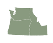
The Northwest, which includes Washington, Oregon, and Idaho, has experienced record-setting episodes of heat, drought, and snowpack loss due to climate change. Davey scientists predict all seasons will continue to warm.
- A warming climate: The plant hardiness zone for Seattle will transition from zone 8 to zone 9 by mid-century, which will change the palette of planting options.
- Precipitation patterns will remain variable: Forecasts also show precipitation increasing throughout the Northwest in winter and spring and decreasing in summer as the climate warms. But rain and snowfall will continue to be highly variable with periods of prolonged drought mixing with years of above-average rainfall.
- Trees and forests are susceptible: Higher temperatures and decreasing summer precipitation have increased trees’ susceptibility to insects and disease. Tree mortality from bark beetles, wildfires, and drought will intensify.
>> View Fact Sheet for the Northwest Region
Southwest Region
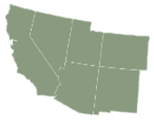
The Southwest was warm, to begin with, but it continues to get even warmer with California and western Colorado experiencing the greatest increases of average annual temperatures at about 3 degrees Fahrenheit. This region includes California, Colorado, Nevada, Arizona, New Mexico, and Utah.
- A warming climate: Average annual temperatures in the Southwest are projected to increase 8.6 degrees Fahrenheit, depending on emissions. Davey scientists expect California to experience 20 to 40 additional days with maximum temperatures of at least 90 degrees Fahrenheit, and Arizona and New Mexico will have at least 40 to 60 additional extreme heat days by the end of the century.
- Increasing megadroughts: Increasing temperatures are intensifying Southwest droughts, particularly in California and the upper Colorado River Basin. Hotter temperatures result in drying earlier in the season and greater evapotranspiration, contributing to megadroughts, which have persisted for a decade or longer.
- Insect outbreaks and wildfires: Tree mortality has doubled over the last 50 years due to drought, wildfires, and insect outbreaks. Warming and drying of the climate has increased wildfire frequency, duration, and season length, doubling the area of forest that has burned on average each year in the western U.S. since 1984. Davey scientists predict the trend will intensify.
>> View Fact Sheet for the Southwest Region
Northern Great Plains
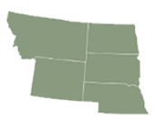
In the Northern Great Plains, which includes Montana, Wyoming, Nebraska, North Dakota, and South Dakota, average annual temperatures have increased from as much as 1 degree Fahrenheit in Nebraska to as much as 3 degrees Fahrenheit in Wyoming as a result of climate change.
- A warming climate: Davey scientists predict extreme heat days to rise with the number of days above 100 degrees Fahrenheit doubling in Wyoming by mid-century. The increasing temperatures will transition plant hardiness zones across the region.
- Variable and unpredictable precipitation: Eastern states will receive more precipitation, while western states will receive less. As the weather becomes more variable, Davey scientists predict summer droughts will be more severe, while flooding will also intensify with more intense rainstorms and associated high precipitation events.
- Declining water availability: Everything from summer droughts to decreased snowpack to shrinking glaciers to a rise in evapotranspiration will lead to continued decreased average flow rates of rivers and streams. Irrigation restrictions will continue to put pressure on tree and plant health and maintenance.
- Changing forests: Forest composition will shift as pines become less dominant, and a warmer climate will favor aspen.
>> View Fact Sheet for the Northern Great Plains
Southern Great Plains
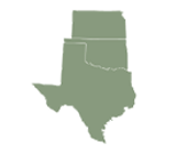
Southern Great Plains states, including Texas, Oklahoma, Kansas, and Nebraska, have warmed 1 to 2 degrees Fahrenheit over the last 100 years with winters having warmed more than summers due to climate change.
- A warming climate: Davey scientists predict warming will intensify with temperatures increasing by 3.6 to 5.1 degrees Fahrenheit by mid-century and 4.4 to 8.4 degrees Fahrenheit by the end of the century.
- Water management and its impact on trees: Since plant growth begins earlier in spring and summers become hotter and extreme heat more frequent, soils will become drier. This trend will intensify tree stress, increasing susceptibility to pests and diseases.
- Hurricane outlook: Sea levels in the Texas Gulf have been rising at twice the global average rate, increasing flooding and hurricanes, which draw their energy from the heat of the warming ocean.
>> View Fact Sheet for the Southern Great Plains
Midwest Region
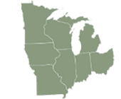
The Midwest region, which includes Minnesota, Iowa, Missouri, Illinois, Wisconsin, Indiana, Michigan, and Ohio, is one of the fastest-warming areas of the continental U.S. with Minnesota having warmed more than 3 degrees Fahrenheit on average due to climate change. Wisconsin and Michigan have warmed 2 degrees Fahrenheit on average, and the southern stretch of the region along the Ohio River has warmed about 1 degree Fahrenheit.
- A warming climate: By the end of the century, Minnesota and Ohio will experience 5 to 15 more days per year with temperatures exceeding 95 degrees Fahrenheit, and Illinois will experience 15 to 20 more days. Michigan’s climate is projected to resemble the current climates of Missouri and Oklahoma, and Illinois that of the current climate of Texas.
- Changing winter hardiness zones: Winters are warming throughout the Midwest, changing plant hardiness zones. Columbus, Ohio has warmed from zone 5 to zone 6 and will reach zone 7 by the second half of the century. Minneapolis and Chicago will transition from zone 4 to zone 6 or even zone 7, depending on future patterns of emissions.
- More rain extremes: Over the last 50 years, average annual precipitation has increased 5% to 10% over most of the Midwest. Midwesterners should expect more rain, extreme rainfall events, and flooding.
- A changing forest: Paper birch, quaking aspen, balsam fir, and black spruce trees will decline, and oak, hickory, and pines will increase due to their heat and drought tolerance.
- Rising tree stress: Higher precipitation and humidity will increase plant diseases, while droughts will dry soils, giving way to more insect infestations.
>> View Fact Sheet for the Midwest Region
Northeast Region
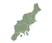
The northeast region extends from West Virginia to Maine. Since the beginning of the 20th century, average annual temperatures have warmed from just under 1 degree Fahrenheit in West Virginia to 3 degrees Fahrenheit in New England as a result of climate change.
- A warming climate: By 2050, average temperatures in the northeast may increase to between 4 and 5 degrees Fahrenheit (depending on global greenhouse gas emissions) with winters becoming milder and spring arriving earlier. USDA plant hardiness zones currently range from zone 6 in West Virginia to zone 4 in Maine, but they are predicted to transition to zones 7 and 5, respectively, by mid-century and zones 8 and 7, respectively, by the end of the century. Scientists predict the growing season will increase by 2 to 3 weeks by mid-century.
- Increasing precipitation: Northeasterners should expect further increases in rainfall and snowfall during the winter and spring. In fact, rainfall intensity has increased more in the Northeast than in any other part of the country, increasing flooding frequency.
- Changing tree species: A longer growing season, increased precipitation, and CO2 will continue to boost forest productivity. In central West Virginia, Davey scientists predict oak and hickory to increase in dominance, while sugar maple, beech, and gray birch will decrease. In northern Maine, spruce-fir forests are projected to transition to maple-beech-birch forests.
- Diseases and pests impacting trees: A warmer, wetter, and more humid climate favors the growth and spread of pathogens and pests. From foliar diseases on white pines increasing defoliation to southern pine beetles spreading to never-before-infested areas like New Jersey, New York, and Massachusetts, Davey scientists predict greater insect and disease pressure.
>> View Fact Sheet for the Northeast Region
Southeast Region
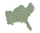
In the Southeast region, which includes Arkansas, Louisiana, Mississippi, Alabama, Tennessee, Kentucky, Virginia, North Carolina, South Carolina, Georgia, and Florida, nights and winters are warming faster than days and summers as a result of climate change. Average daily minimum temperatures have actually increased 3 times faster than average daily maximum temperatures.
- An unevenly warming climate: Davey scientists predict winters will continue to warm throughout the region, and summer heatwaves will continue to become more frequent, intense, and longer. Daily maximum temperatures above 95 degrees Fahrenheit could become the norm, with temperatures above 100 degrees Fahrenheit becoming more frequent during summer. This will move plant hardiness zones from 8a to 9a along the Gulf coast and 6b to 7b in central Kentucky by mid-century.
- Expect extreme precipitation: Heavy downpours and flooding will increase by 2050. Even as total rainfall increases, intermittent summer droughts will become more frequent as well. Add to those hotter days and drier soils.
- More hurricanes and flooding: Hurricanes draw their energy from the heat of the ocean, which is warming. The frequency of strong hurricanes -- classes 4 and 5 -- as well as associated precipitation and flooding, has increased substantially, as a result. Davey scientists predict the trend to intensify.
- A changing forest: Wildfires ignited by lightning are expected to rise an average of 30% throughout the region by 2060. More intense droughts will impact the forests; oaks may increase in dominance at the expense of loblolly and shortleaf pines in southern regions of the Southeast, while beech and maple will decline as oak and hickory increase in central Kentucky.
>> View Fact Sheet for the Southeast Region
CHECK OUT OUR CLIMATE CHANGE RESOURCES TO LEARN MORE ABOUT OUR CHANGING CLIMATE AND THE IMPACTS TO YOUR REGION’S GREEN SPACES.
Related Blog Posts

How Do Trees Help Fight Climate Change?